
Jog Falls Viewing Decks
Two vantage points offering panoramic views of all four cascades.
Offbeat Karnataka
Karnataka, India· Last updated
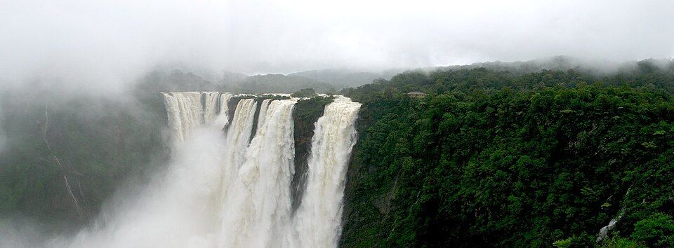

The most dramatic window, when monsoon runoff and dam releases give the falls their fullest flow.
Nearest Airport
Jog Falls, in Shimoga district, is formed by the Sharavathi River dropping over 253 meters in a series of four distinctly named cascades — Raja, Rani, Roarer, and Rocket — through dense Western Ghats forest, ranking among India's highest waterfalls. Unlike waterfalls fed by unregulated rivers, Jog's flow is affected by the operation of the Linganamakki Dam upstream, meaning the falls are at their most dramatic during and shortly after monsoon, when excess water is released, and considerably reduced during the dry season. Jog Falls suits travelers who want a genuinely dramatic natural spectacle as a focused stop rather than an extended base — two viewing decks offer panoramic vantage points over the full cascade, and while a steep staircase down toward the base was historically a popular (if strenuous) way to get closer to the falls, current access can vary with monsoon conditions and should be checked locally. The surrounding Sharavathi Valley Wildlife Sanctuary and the nearby Linganamakki Dam add context and additional short excursions for those extending their visit, while Jog's position roughly midway between Gokarna and Chikmagalur makes it a natural stop on a wider Western Ghats-and-coast itinerary.
Jog Falls Viewing Decks
Two vantage points offering panoramic views of all four cascades.
Linganamakki Dam
The dam upstream on the Sharavathi River, roughly 6 km from the falls.
Sharavathi Valley Wildlife Sanctuary
The forest reserve surrounding the falls.
Talakalale Dam
A smaller balancing reservoir near Jog Falls.
Honnemaradu
A nearby backwater destination on the Sharavathi reservoir, popular for camping and water sports.
The TripDnD Rate
Planning a stay in Jog Falls?
Send us the property you're considering — anywhere online. Our rate desk works our partner network and negotiates a better rate for you. No booking fee.
Free to ask. You decide once you see the rate.
Nearest Airport: Hubballi Airport, approx. 159 km; Mangaluru International Airport, approx. 217 km. Nearest Railway Station: Talaguppa Railway Station, approx. 13–18 km; Sagara, approx. 36 km, for wider connectivity. By Road: From Shivamogga (Shimoga), drive via Sagara to Jog Falls, roughly 100 km, taking approximately 2.5–3 hours; regular buses run from Bengaluru, Shivamogga, and Gokarna.
July–October: The most dramatic window, when monsoon runoff and dam releases give the falls their fullest flow. November–February: Reduced flow but still visible and scenic, with more comfortable weather for viewing. March–June: The falls can reduce to a trickle or stop entirely outside of scheduled dam releases.
A half-day to full-day visit covers the viewing decks and nearby dam comfortably.
Yes, the main viewing decks require minimal walking; access to the base of the falls varies by season and current conditions.
July through October, during and shortly after peak monsoon.
Linganamakki Dam, Honnemaradu, and Sharavathi Valley Wildlife Sanctuary.
Search any offbeat valley, village or state across India.
More to explore: offbeat places in Karnataka · all offbeat India · holiday packages